


arsel les plantiers

labarone
User
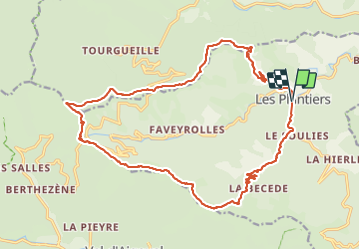

Length
23 km

Max alt
1028 m

Uphill gradient
828 m
Km-Effort
34 km

Min alt
408 m

Downhill gradient
827 m
Boucle
Yes
Creation date :
2023-11-07 08:11:19.572
Updated on :
2023-11-07 15:35:26.135
6h53
Difficulty : Medium

FREE GPS app for hiking
 SityTrail
IGN / Geographical institutes
SityTrail Plus
The world is yours!
About
Trail Walking of 23 km to be discovered at Occitania, Gard, Les Plantiers. This trail is proposed by labarone.
Description
un peu longue mais cool
Photos


Positioning
Country:
France
Region :
Occitania
Department/Province :
Gard
Municipality :
Les Plantiers
Location:
Unknown
Start:(Dec)
Start:(UTM)
557848 ; 4885043 (31T) N.
Comments